
The longest highways in the United States cut through deserts, forests, mountains, and coastlines, offering unmatched variety.
Road trips along these routes reveal hidden towns, shifting landscapes, and the real character of the country.
Here are the twelve longest highways that define the American road.
- U.S. Route 20 – 3,365 miles
- U.S. Route 6 – 3,207 miles
- U.S. Route 30 – 3,073 miles
- Interstate 90 – 3,021 miles
- U.S. Route 50 – 3,011 miles
- Interstate 80 – 2,899 miles
- U.S. Route 60 – 2,670 miles
- U.S. Route 2 – 2,571 miles
- Interstate 40 – 2,555 miles
- U.S. Route 12 – 2,484 miles
- U.S. Route 1 – 2,369 miles
- U.S. Route 41 – 2,008 miles
1. U.S. Route 20

| Length | 3,365 miles |
| Western Terminus | Newport, Oregon |
| Eastern Terminus | Boston, Massachusetts |
| States Covered | Oregon, Idaho, Montana, Wyoming, Nebraska, Iowa, Illinois, Indiana, Ohio, Pennsylvania, New York, Massachusetts |
| Notable Cities | Portland, Chicago, Cleveland, Boston |
| Established | 1926 |
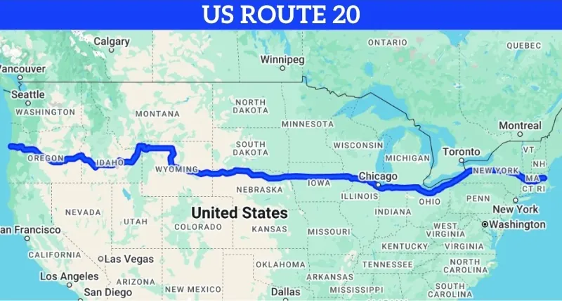
U.S. Route 20, the longest road in the country, stretches from coast to coast, beginning in Newport, Oregon, and ending in Boston, Massachusetts.
Covering 3,365 miles, this highway takes travelers on a journey through some of America’s most diverse regions, from the rocky Pacific Northwest to the bustling streets of Boston.
Known as the “Big Daddy” of U.S. highways, Route 20 passes through twelve states, each offering unique sights, landscapes, and cultural landmarks along the way.
It’s an ideal route for those looking to experience the true breadth of the United States.
Sights to See Along U.S. Route 20
Crater Lake National Park, Oregon
Starting on the western end, Route 20 brings travelers close to Crater Lake National Park, famous for its deep blue waters and stunning caldera.
The park offers opportunities for hiking, photography, and experiencing one of the most scenic locations in Oregon.
Yellowstone National Park, Wyoming
As you travel further east, Route 20 leads to the entrance of Yellowstone National Park, one of the most iconic natural attractions in the country.
Known for its geysers, hot springs, and wildlife, Yellowstone offers an unforgettable experience in nature’s grandeur.
Chicago, Illinois
Illinois brings Route 20 through Chicago, a city known for its architecture, skyline views, and deep cultural depth.
Visitors can walk through Millennium Park, explore the Art Institute, and experience the sound of the L train curving above downtown streets.
A stop in Chicago is incomplete without a deep-dish pizza, a signature flavor born in 1943 and still served piping hot in neighborhoods across the city.
Finger Lakes, New York
Eastward, Route 20 reveals the Finger Lakes region, where glacier-carved valleys now hold clear lakes surrounded by vineyards.
The area offers quiet roads, hillside wineries, and towns with old stone churches, historic inns, and handmade goods.
Travelers find peaceful views and local pride in every small stop.
Boston, Massachusetts
Route 20 reaches its final point in Boston, a city where cobblestone streets meet harborside history.
Walk the Freedom Trail to trace America’s fight for independence. Rest at Boston Common where quiet meets civic life. Stand aboard the Boston Tea Party Ships and picture the harbor as it was during rebellion.
Route 20 ends here, but Boston opens the door to the Atlantic and to the echoes of every story traveled along the way.
2. U.S. Route 6
| Length | 3,207 miles |
| Western Terminus | Bishop, California |
| Eastern Terminus | Provincetown, Massachusetts |
| States Covered | California, Nevada, Utah, Colorado, Nebraska, Iowa, Illinois, Indiana, Ohio, Pennsylvania, New York, Connecticut, Rhode Island, Massachusetts |
| Notable Cities | Denver, Cleveland, Des Moines, Providence |
| Established | 1936 |
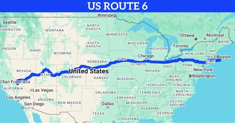
U.S. Route 6, known as the “Grand Army of the Republic Highway,” covers 3,207 miles between Bishop, California and Provincetown, Massachusetts.
Route 6 carries the legacy of early American road-building. Fourteen states shape the route with a mix of plains, peaks, cities, and coast. Each section adds a different rhythm to the path across the country.
Sights to See Along U.S. Route 6
Sierra Nevada Mountains, California
Beginning in Bishop, the highway moves along the eastern edge of the Sierra Nevada range. Granite faces rise above desert stretches. The air grows colder with altitude. Roads shift beside alpine lakes. The land holds silence and sharp wind, offering a bold start to the journey.
Rocky Mountain National Park, Colorado
In Colorado, travelers can follow a short detour into Rocky Mountain National Park. Snow-capped peaks surround valleys carved by ancient rivers. Herds move quietly through clearings. Air shifts fast at elevation. The park’s altitude, color, and echo make every view exact and real.
Des Moines, Iowa
Midway through, Route 6 passes through Des Moines. The Capitol dome rises above low buildings. Murals color alley walls. Market stands fill city blocks on weekends. The stop adds urban calm and Midwest balance to the cross-country path.
Cuyahoga Valley National Park, Ohio
In Ohio, Route 6 gives access to Cuyahoga Valley National Park. Waterfalls cut through thick forest. Trains follow river bends. Wooden paths wind between ferns and rock ledges. The park calms the pace and frames each mile with green and stone.
Provincetown, Massachusetts
The highway ends at Provincetown, where narrow streets curve beside dunes and harbors. Art hangs in bright storefronts. Lighthouses rise beyond sandy walks. Shipwrecks, whaling logs, and coastal voices fill the museums. Route 6 closes at the edge of Cape Cod, where land meets Atlantic and stories pause in the sea breeze.
3. U.S. Route 30

| Length | 3,073 miles |
| Western Terminus | Astoria, Oregon |
| Eastern Terminus | Atlantic City, New Jersey |
| States Covered | Oregon, Idaho, Wyoming, Nebraska, Iowa, Illinois, Indiana, Ohio, Pennsylvania, New Jersey |
| Notable Cities | Portland, Fort Wayne, Chicago, Philadelphia |
| Established | 1926 |
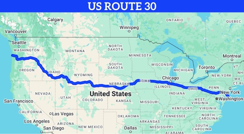
U.S. Route 30 covers 3,073 miles from Astoria, Oregon, on the Pacific coast, to Atlantic City, New Jersey, on the Atlantic shore.
Known in segments as the “Lincoln Highway,” Route 30 stands among the earliest coast-to-coast highways in the country. It weaves through farmland, cities, and hills, reflecting many layers of American movement, conflict, and growth.
Sights to See Along U.S. Route 30
Columbia River Gorge, Oregon
At the western start, the highway traces the Columbia River Gorge. Waterfalls break through cliff walls. Wind moves past basalt towers. Hikers and drivers share views of river bends, bridges, and historic highways. The start offers quiet beauty with wide skies and steep rock layers.
Fort Wayne, Indiana
In Indiana, Route 30 flows through Fort Wayne. The Fort Wayne Children’s Zoo and Science Central offer family-friendly stops. Local diners line the streets. The city balances activity with calm neighborhoods and welcoming streetscapes.
Chicago, Illinois
Chicago rises beyond Indiana’s edge. Travelers on Route 30 can reach Millennium Park, the Art Institute, and the wide curves of the Riverwalk. Public art fills corners. Skyscrapers tower above lake winds. The blend of culture, history, and street flavor offers a sharp contrast to the quieter roads behind.
Gettysburg National Military Park, Pennsylvania
As the highway cuts through Pennsylvania, it reaches Gettysburg National Military Park. Fields stretch wide where history settled in blood and smoke.
Memorials mark movement. Trails pass monuments and cannon rows. The park remains one of the most significant places to trace American memory and war.
Atlantic City, New Jersey
The road ends with waves, neon, and salt air. Atlantic City opens with wide boardwalks, sea views, and casino towers.
Streets blend old beach houses and modern glass. The coast shapes the final mood of the trip with energy, lights, and shoreline sound.
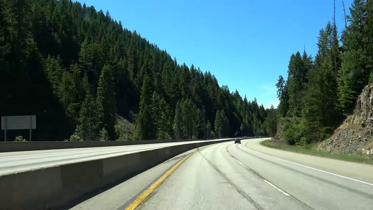
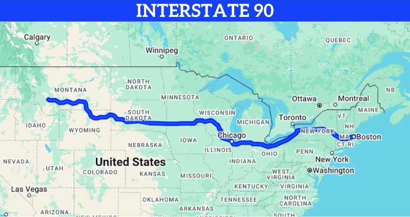
4. Interstate 90
| Length | 3,021 miles |
| Western Terminus | Seattle, Washington |
| Eastern Terminus | Boston, Massachusetts |
| States Covered | Washington, Idaho, Montana, Wyoming, South Dakota, Minnesota, Wisconsin, Illinois, Indiana, Ohio, Pennsylvania, New York, Massachusetts |
| Notable Cities | Seattle, Chicago, Cleveland, Boston |
| Established | 1956 |
Interstate 90 (I-90) spans 3,021 miles, making it the longest interstate in the U.S.
This major route runs from Seattle, Washington, to Boston, Massachusetts, connecting the Pacific Northwest with the northeastern U.S.
I-90 travels through thirteen states, cutting across the Northern Plains, the Great Lakes region, and into New England.
Known for both its urban and rural stretches, I-90 offers travelers a direct path to explore diverse landscapes, national landmarks, and some of America’s largest cities.
- Here is a random fun fact to know about Washington: They recently adopted two pandas from China. So, another reason to plan your next trip there.
Sights to See Along Interstate 90
Seattle, Washington
Starting in Seattle, I-90 begins near iconic attractions such as the Space Needle and Pike Place Market.
Badlands National Park, South Dakota
Further along I-90, travelers can visit Badlands National Park in South Dakota.
Known for its striking rock formations and rich fossil beds, this park offers a unique landscape and plenty of opportunities for hiking and photography.
Chicago, Illinois
In Illinois, I-90 passes through Chicago, giving travelers a chance to explore the city’s skyline, cultural institutions, and famous deep-dish pizza.
Must-see spots include the Art Institute of Chicago, Millennium Park, and Navy Pier, offering a blend of art, nature, and urban charm.
Niagara Falls, New York
Just off I-90, Niagara Falls serves as a dramatic natural landmark that is worth the detour.
With its powerful waterfalls and surrounding parks, Niagara Falls offers stunning views and boat tours for those who want to get close to the falls.
Boston, Massachusetts
I-90 concludes in historic Boston, known for its colonial history, cobblestone streets, and vibrant neighborhoods.
Travelers can explore the Freedom Trail, Quincy Market, and Boston Common, making this a memorable end to a cross-country adventure.
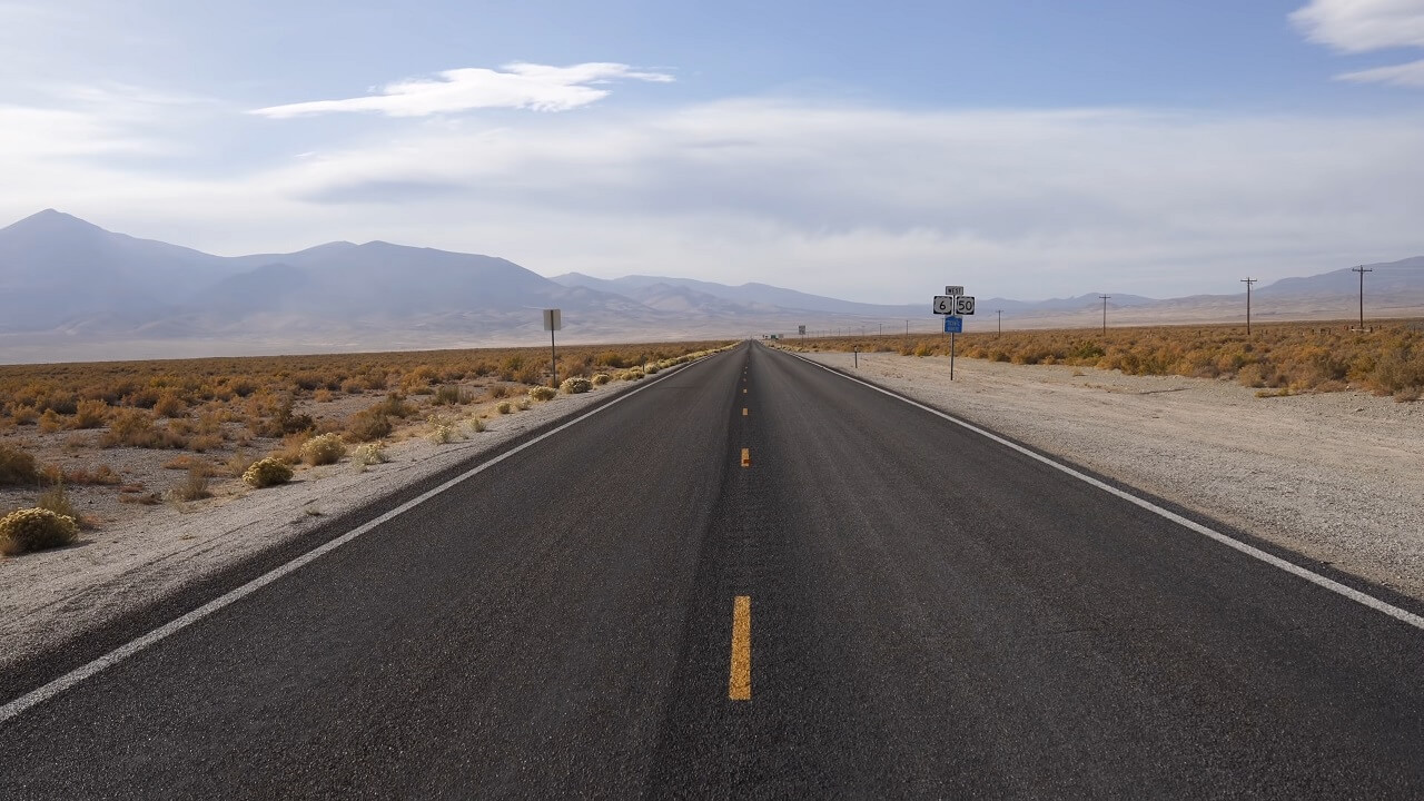
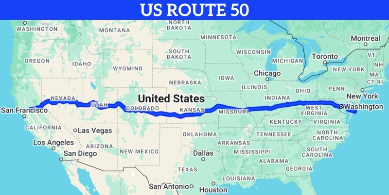
5. U.S. Route 50
| Length | 3,011 miles |
| Western Terminus | Sacramento, California |
| Eastern Terminus | Ocean City, Maryland |
| States Covered | California, Nevada, Utah, Colorado, Kansas, Missouri, Illinois, Indiana, Ohio, West Virginia, Virginia, Maryland |
| Notable Cities | Sacramento, Kansas City, St. Louis, Cincinnati |
| Established | 1926 |
U.S. Route 50, often called “The Loneliest Road in America,” stretches 3,011 miles from Sacramento, California, to Ocean City, Maryland.
Known for its stretches of remote and scenic highway, Route 50 is perfect for travelers looking for both solitude and adventure across America’s diverse terrains.
Sights to See Along U.S. Route 50
Lake Tahoe, California
Starting near Sacramento, Route 50 takes travelers close to Lake Tahoe, a stunning alpine lake known for its crystal-clear waters and surrounding mountains.
Visitors can enjoy activities like hiking, boating, or simply taking in the breathtaking views of this natural gem.
Great Basin National Park, Nevada
In Nevada, Route 50 crosses through the Great Basin National Park. A quiet and lesser-visited park known for its ancient bristlecone pines, limestone caves, and high desert beauty.
Kansas City, Missouri
As Route 50 passes through Missouri, travelers can stop in Kansas City, a lively city known for its jazz heritage, barbecue, and historic districts.
Hocking Hills State Park, Ohio
Further along in Ohio, Route 50 provides access to Hocking Hills State Park.
It offers excellent opportunities for hiking and outdoor exploration, making it a refreshing stop for nature enthusiasts.
Ocean City, Maryland
The eastern end of Route 50 concludes in Ocean City, Maryland.
It is a popular destination for relaxation and recreation, providing an enjoyable finale to the cross-country drive.
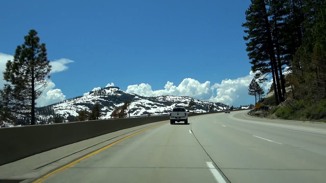
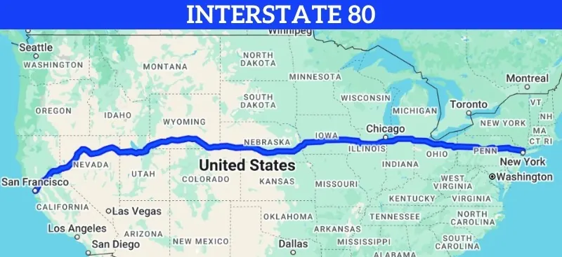
6. Interstate 80
| Length | 2,899 miles |
| Western Terminus | San Francisco, California |
| Eastern Terminus | Teaneck, New Jersey |
| States Covered | California, Nevada, Utah, Wyoming, Nebraska, Iowa, Illinois, Indiana, Ohio, Pennsylvania, New Jersey |
| Notable Cities | San Francisco, Salt Lake City, Omaha, Chicago |
| Established | 1956 |
Interstate 80 (I-80) covers 2,899 miles, stretching from San Francisco, California, to Teaneck, New Jersey.
I-80 traverses diverse landscapes, including the Sierra Nevada mountains, the expansive plains, and industrial cities of the Midwest.
It’s an essential route for anyone interested in seeing the contrasting regions and iconic landmarks spread across the northern U.S.
Sights to See Along Interstate 80
Golden Gate Bridge, San Francisco
I-80 begins in San Francisco, allowing travelers to start their journey with a view of the Golden Gate Bridge and nearby Fisherman’s Wharf.
Bonneville Salt Flats, Utah
Further along I-80, travelers pass through the Bonneville Salt Flats in Utah, known for their otherworldly landscape and land speed records.
Chicago, Illinois
As I-80 continues east, it passes through Chicago, where travelers can explore the city’s renowned museums, waterfront views, and unique culinary scene.
Chicago provides a vibrant stop with endless attractions, from architecture tours to famous deep-dish pizza.
Indiana Dunes National Park, Indiana
Located on Lake Michigan’s southern shore, Indiana Dunes National Park offers sandy beaches, hiking trails, and scenic dunes.
Delaware Water Gap, Pennsylvania
In Pennsylvania, I-80 leads to the Delaware Water Gap, a scenic area where the Delaware River cuts through a mountain ridge.
The area features hiking, canoeing, and overlooks that capture the natural charm of the Appalachian Mountains.
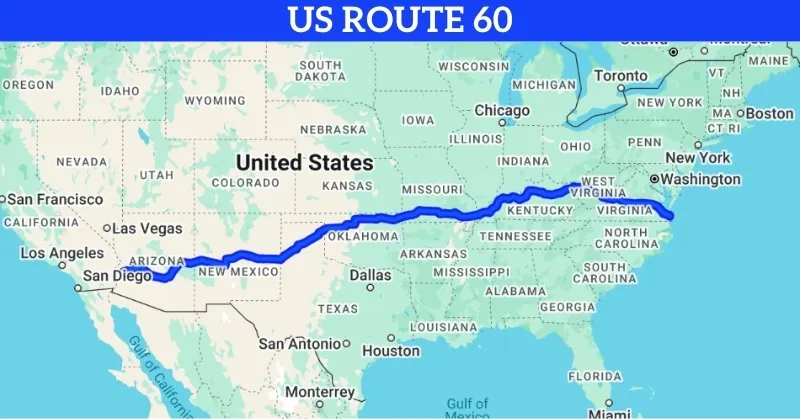
7. U.S. Route 60
| Length | 2,670 miles |
| Western Terminus | Brenda, Arizona |
| Eastern Terminus | Virginia Beach, Virginia |
| States Covered | Arizona, New Mexico, Texas, Oklahoma, Missouri, Kentucky, West Virginia, Virginia |
| Notable Cities | Phoenix, Amarillo, Louisville, Charleston |
| Established | 1926 |
U.S. Route 60 stretches 2,670 miles, connecting the deserts of Arizona to the Atlantic shores of Virginia.
Known for its scenic and varied route, Route 60 travels through mountain ranges, farmlands, and historic towns across eight states.
Originally part of the main route to California before the interstates, Route 60 remains a beloved highway for those seeking a blend of quiet backroads and scenic landscapes.
Sights to See Along U.S. Route 60
Tonto National Forest, Arizona
Beginning in Arizona, Route 60 passes through the Tonto National Forest. This area offers lush forests, desert landscapes, and scenic mountain views, providing an exciting start to the journey.
Cadillac Ranch, Amarillo, Texas
In Texas, Route 60 brings travelers near Amarillo, where they can visit the famous Cadillac Ranch.
Daniel Boone National Forest, Kentucky
As Route 60 crosses into Kentucky, travelers can explore the scenic Daniel Boone National Forest.
Known for its cliffs, waterfalls, and trails, this forest offers a peaceful retreat into nature and is an ideal stop for outdoor enthusiasts.
Charleston, West Virginia
Further east, Route 60 passes through Charleston, the capital of West Virginia. Here, visitors can explore the state’s history, take a stroll along the Kanawha River, or visit the State Capitol building, known for its gold dome.
Virginia Beach, Virginia
The journey concludes in Virginia Beach, where travelers can enjoy the oceanfront, boardwalk, and various seaside attractions.
The sandy shores and relaxed vibe offer the perfect ending to a cross-country drive.
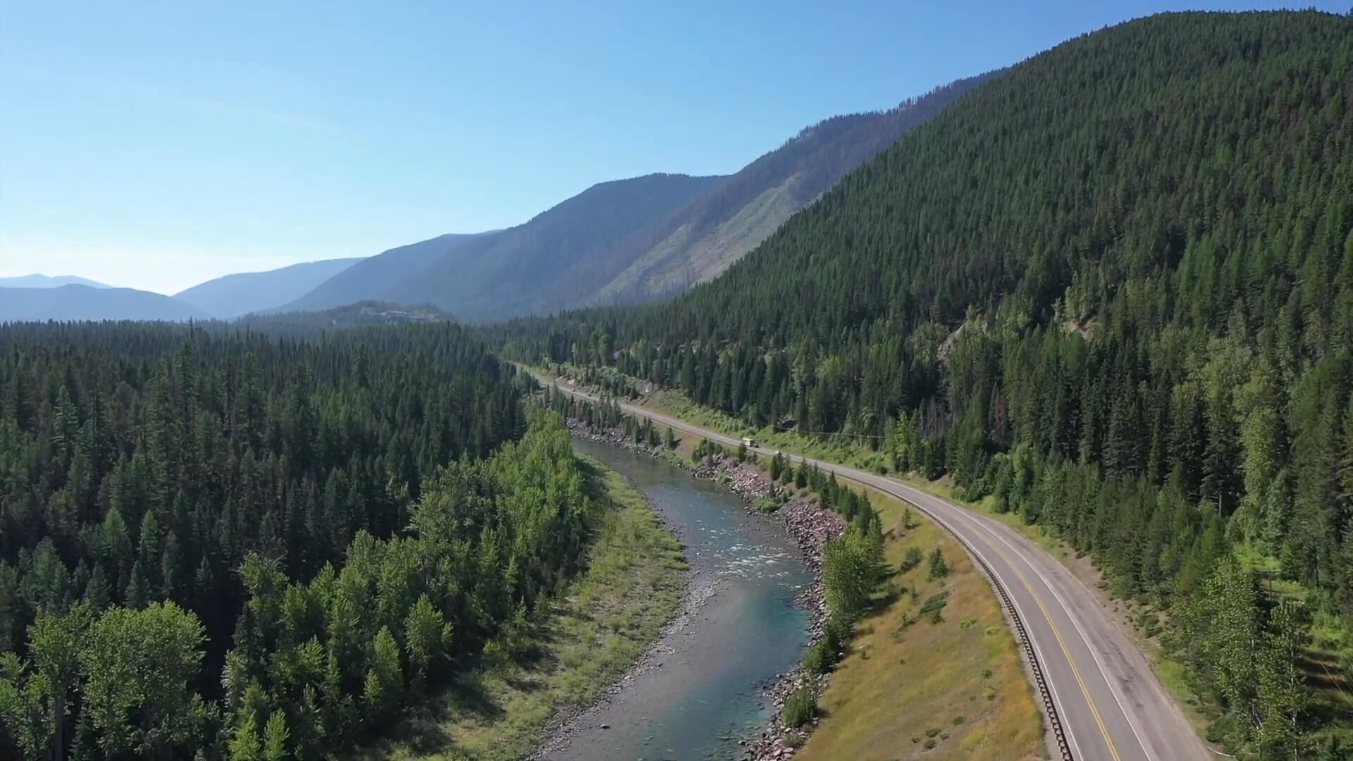
8. U.S. Route 2
| Length | 2,571 miles |
| Western Terminus | Everett, Washington |
| Eastern Terminus | Houlton, Maine |
| States Covered | Washington, Idaho, Montana, North Dakota, Minnesota, Wisconsin, Michigan, Vermont, New Hampshire, Maine |
| Notable Cities | Spokane, Duluth, Grand Forks, Bangor |
| Established | 1926 |
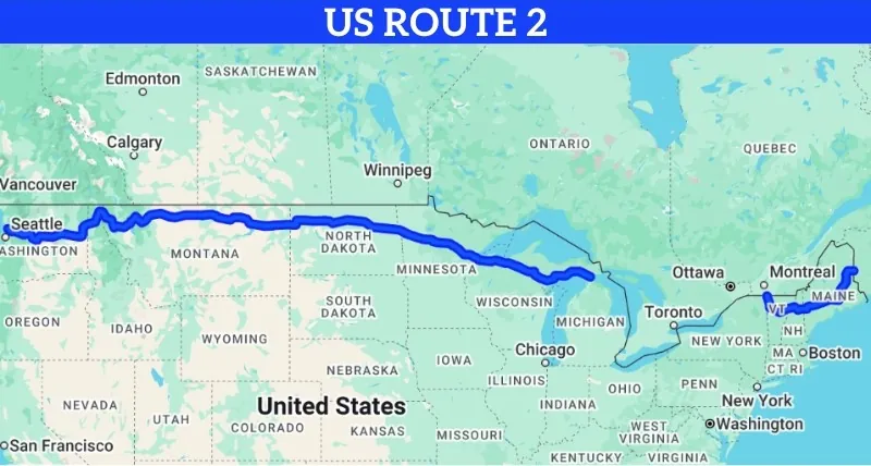
U.S. Route 2 runs 2,571 miles across the northernmost part of the country. It begins in Washington state and ends in Maine’s far northeast. Every mile reflects open roads, quiet views, and moments far from crowded highways.
Often called the “Great Northern” route, it offers a remote and scenic path. The road passes through forests, mountains, and parks. Towns sit apart by long stretches of rural land. Travelers seeking quiet routes and broad landscapes will find meaning here.
Sights to See Along U.S. Route 2
Glacier National Park, Montana
Montana offers a standout view near Glacier National Park. Peaks stretch into the sky. Waterfalls run through forests. Trails lead across meadows and past wildlife. The park carries both beauty and challenge, making it one of the most rewarding detours on the route.
Theodore Roosevelt National Park, North Dakota
Further east, travelers can visit Theodore Roosevelt National Park. Badlands formations rise in waves. Prairie dogs dart across trails. Views of painted hills line the horizon. The park honors the conservation legacy of Roosevelt with silent strength and wide skies.
Lake Superior, Minnesota
Route 2 hugs the southern edge of Lake Superior in Minnesota. The lake’s size overwhelms the eye. Small ports and quiet beaches appear between dense green forests. Wind moves across the water with force. Few stretches on the highway offer a view this vast or water this powerful.
White Mountain National Forest, New Hampshire
In New Hampshire, the road climbs into the White Mountain National Forest. Roads curl around valleys. Trails pass old trees.
Leaves turn brilliant colors in autumn. Each mile in this forest offers another quiet and scenic moment.
Houlton, Maine
The trip ends in Houlton, Maine. Forests surround the town. Logging history and old architecture mark the streets.
Travelers can pause here before heading toward the Canadian border. The finish feels remote, but peaceful, with echoes of all the land covered behind.
9. Interstate 40

| Length | 2,555 miles |
| Western Terminus | Barstow, California |
| Eastern Terminus | Wilmington, North Carolina |
| States Covered | California, Arizona, New Mexico, Texas, Oklahoma, Arkansas, Tennessee, North Carolina |
| Notable Cities | Albuquerque, Oklahoma City, Memphis, Nashville |
| Established | 1957 |
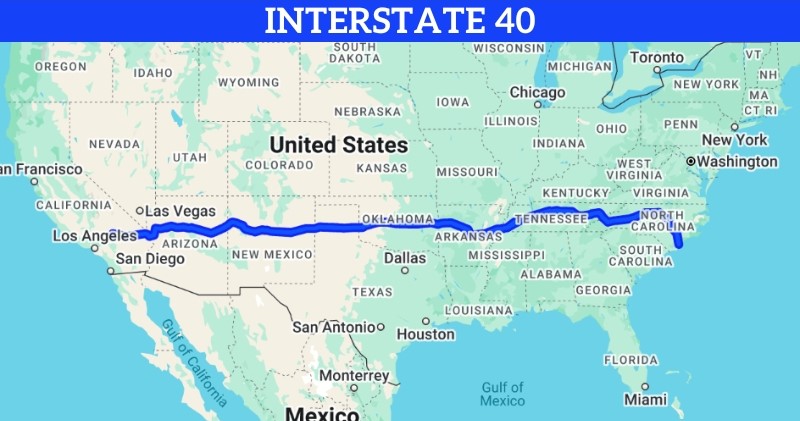
Interstate 40 covers 2,555 miles across the southern United States. It begins in Barstow, California, and ends in Wilmington, North Carolina. The route traces parts of the old Route 66 and carries travelers through deserts, plains, hills, and cities. The road tells stories through each turn of scenery.
I-40 links both coasts with steady pace and steady shifts. Each section opens new views. Travelers find historic landmarks, natural parks, and city energy across six time zones. The route remains one of the most driven paths in the lower 48.
Sights to See Along Interstate 40
Petrified Forest National Park, Arizona
In eastern Arizona, I-40 passes near Petrified Forest National Park. Ancient trees turned to stone lie across the desert floor.
Colorful rocks and fossil beds stretch for miles. The silence in the air feels untouched. Every trail leads into deep time.
Albuquerque, New Mexico
Further east, I-40 cuts through Albuquerque. Adobe buildings and red sunsets shape the landscape.
The city holds art galleries, historic plazas, and the International Balloon Fiesta. Old Town streets blend with the smell of chile in the air. Travelers pause here for beauty, color, and heat.
Oklahoma City, Oklahoma
I-40 rolls straight into Oklahoma City. The National Cowboy & Western Heritage Museum brings the Old West to life. Nearby, the Oklahoma City National Memorial offers quiet reflection. Rodeos, diners, and wide roads stretch around the city limits. Everything here speaks of plains and history.
Great Smoky Mountains, Tennessee and North Carolina
On the eastern end, the interstate climbs toward the Great Smoky Mountains. Mist lifts over ridges. Streams run beside the highway. Fall brings color to every slope.
The park invites hikers, campers, and drivers alike. Few places close a highway journey with more natural weight than these mountains.
Wilmington, North Carolina
The eastern end of I-40 concludes in Wilmington, a coastal city with historic charm, beaches, and a lively riverfront. Wilmington’s seaside attractions provide a relaxing and scenic end to a cross-country journey.
10. U.S. Route 12
| Length | 2,484 miles |
| Western Terminus | Aberdeen, Washington |
| Eastern Terminus | Detroit, Michigan |
| States Covered | Washington, Idaho, Montana, North Dakota, South Dakota, Minnesota, Wisconsin, Illinois, Indiana, Michigan |
| Notable Cities | Minneapolis, Chicago, Gary, Detroit |
| Established | 1926 |
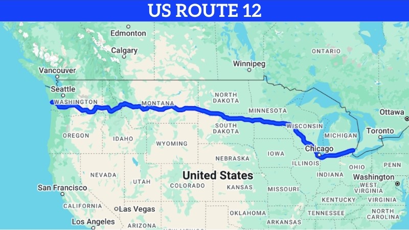
U.S. Route 12 spans 2,484 miles, running from Aberdeen, Washington, to Detroit, Michigan. This historic highway crosses through the northern United States, offering travelers a mix of mountain scenery, farmlands, and urban landscapes.
Route 12 is known for its rich history, following sections of the Lewis and Clark expedition route and passing through some of the most scenic areas in the northern Midwest.
Sights to See Along U.S. Route 12
Mount Rainier National Park, Washington
Starting in Washington, Route 12 provides access to Mount Rainier National Park. Known for its iconic snow-capped peak, dense forests, and wildflower-filled meadows, this park offers breathtaking views and numerous trails for outdoor enthusiasts.
Missoula, Montana
As Route 12 continues through Montana, it passes near Missoula, a city surrounded by stunning mountain landscapes. Missoula is a welcoming stop with a thriving arts scene, historic downtown, and outdoor activities along the Clark Fork River.
Wisconsin Dells, Wisconsin
In Wisconsin, Route 12 takes travelers through the Wisconsin Dells, a popular destination known for its scenic river, unique rock formations, and family-friendly attractions.
Chicago, Illinois
Route 12 runs through Chicago, offering travelers a chance to experience the city’s renowned museums and architecture.
Chicago’s mix of urban culture and lakeside beauty makes it a must-see stop on this route.
Detroit, Michigan
The eastern end of Route 12 concludes in Detroit, known for its rich automotive history, cultural institutions, and revitalized downtown.
Travelers can explore the Detroit Institute of Arts, historic neighborhoods, and the Detroit Riverwalk, providing an exciting finish to this northern journey.
11. U.S. Route 1

| Length | 2,369 miles |
| Northern Terminus | Fort Kent, Maine |
| Southern Terminus | Key West, Florida |
| States Covered | Maine, New Hampshire, Massachusetts, Rhode Island, Connecticut, New York, New Jersey, Pennsylvania, Delaware, Maryland, Virginia, North Carolina, South Carolina, Georgia, Florida |
| Notable Cities | Boston, New York City, Philadelphia, Miami |
| Established | 1926 |
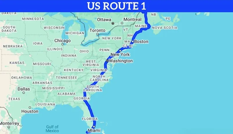
U.S. Route 1 spans 2,369 miles, running along the East Coast from Fort Kent, Maine, to Key West, Florida.
Known as the “Atlantic Highway,” Route 1 passes through major cities, coastal towns, and historic sites, providing a unique way to explore the diversity of the eastern United States.
As one of the oldest and most historic routes, it offers travelers a front-row view to centuries of American history and culture.
Sights to See Along U.S. Route 1
Acadia National Park, Maine
Starting in Maine, Route 1 passes near Acadia National Park. This park is renowned for its rugged coastlines, forested trails, and views from Cadillac Mountain.
It’s an ideal stop for nature enthusiasts seeking a peaceful beginning to their journey.
Boston, Massachusetts
Further south, Route 1 brings travelers into Boston, where they can explore historic landmarks like the Freedom Trail, Boston Common, and the Boston Tea Party Ships.
New York City, New York
As Route 1 passes through New York, it offers travelers the chance to experience New York City’s renowned attractions, from Times Square to Central Park.
Washington, D.C.
In the nation’s capital, travelers can explore the National Mall, the Lincoln Memorial, and the Smithsonian museums.
Washington, D.C., offers a blend of history and cultural attractions, making it a meaningful stop along the route.
Key West, Florida
The journey concludes in Key West, Florida, famous for its tropical atmosphere, colorful architecture, and amazing nightlife.
Key West’s beaches, lively Duval Street, and the Southernmost Point landmark provide a scenic and lively end to the cross-country route.
12. U.S. Route 41
| Length | 2,008 miles |
| Northern Terminus | Copper Harbor, Michigan |
| Southern Terminus | Miami, Florida |
| States Covered | Michigan, Wisconsin, Illinois, Indiana, Kentucky, Tennessee, Georgia, Florida |
| Notable Cities | Chicago, Nashville, Atlanta, Miami |
| Established | 1926 |
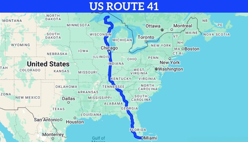
U.S. Route 41 spans 2,008 miles from the northern reaches of Michigan down to the tropical city of Miami, Florida.
Route 41 is known for its blend of urban centers and scenic countryside, making it an appealing choice for travelers who wish to experience both city life and natural beauty along the way. It is one of the most interesting highways in terms of what you can discover during the trip.
Sights to See Along U.S. Route 41
Pictured Rocks National Lakeshore, Michigan
Starting near the top of Michigan, Route 41 offers access to Pictured Rocks National Lakeshore along Lake Superior.
Chicago, Illinois
As Route 41 heads south, it passes through Chicago, where travelers can explore iconic attractions such as Millennium Park, the Art Institute of Chicago, and the Chicago Riverwalk.
Mammoth Cave National Park, Kentucky
In Kentucky, Route 41 takes travelers near Mammoth Cave National Park, home to the world’s longest cave system.
With guided tours and hiking trails, this park provides a fascinating underground adventure and a peaceful retreat into nature.
Nashville, Tennessee
Further south, Route 41 brings travelers through Nashville, the heart of country music. Nashville’s live music venues, historic sites, and vibrant downtown make it a lively stop filled with Southern charm.
Miami, Florida
Route 41 concludes in Miami, Florida, where travelers can enjoy the beaches, vibrant nightlife, and unique Art Deco architecture of South Beach.
For a fun comparison, Interstate 15, a road with a similar size to Route 41, cuts through the deserts of Southern California, where you will see the abandoned Ivanpah solar field. It was once promoted as the largest solar project in the country, but the site never lived up to its promise.
Why Route 66 is No Longer a Highway?
Route 66, often referred to as the “Mother Road,” was once the most famous highway in the United States, stretching from Chicago to Santa Monica and passing through numerous small towns, deserts, and scenic spots along the way.
Established in 1926, it became a symbol of freedom, adventure, and the spirit of the American road trip.
However, Route 66 was officially removed from the U.S. Highway System in 1985. This change occurred because the interstate highway network, which began development in the 1950s, gradually replaced Route 66 with faster, more direct routes that bypassed many of the towns it had originally connected.
The construction of Interstate highways like I-40, I-44, and I-55 made the journey faster but left Route 66 largely obsolete, as travelers now preferred the more efficient roads. As a result, Route 66 was decommissioned and lost its official highway designation.
Although no longer an official highway, Route 66 remains a cherished route for nostalgic travelers, with many sections designated as “Historic Route 66.”
FAQs
How are U.S. highways different from interstates?
U.S. highways and interstates differ mainly in design, speed, and purpose. Interstates are limited-access highways with controlled entry and exit points, designed for faster, long-distance travel. U.S. highways, on the other hand, often pass through towns and cities, allowing for more local access and slower travel speeds.
What is the oldest U.S. highway?
The oldest U.S. highway is U.S. Route 1, which was established in 1926. It runs along the East Coast, connecting Maine to Florida and following some of the country’s oldest travel routes.
How are highway numbers chosen in the U.S.?
Highway numbers in the U.S. are based on a standardized system. East-west routes are typically even-numbered, with lower numbers in the north and higher numbers in the south. North-south routes are odd-numbered, with lower numbers in the east and higher numbers in the west.
Why are some highways called “scenic byways”?
Some highways are designated as “scenic byways” due to their natural beauty, historical significance, or cultural importance. These routes offer travelers unique views and experiences, encouraging exploration beyond the main highways.
Can you drive coast to coast on U.S. longest highways only?
Yes, it is possible to drive coast to coast using only U.S. highways, though it may take longer than using interstates. Routes like U.S. 20 and U.S. 50 offer coast-to-coast travel options for those interested in a scenic, historic journey.
Do all highways have tolls?
Not all highways have tolls. Tolls are typically found on specific interstates, expressways, and bridges to help fund maintenance. Most U.S. highways do not have tolls, allowing for free travel across the network.
What is the difference between a highway and a freeway?
A highway is a general term for any major road, while a freeway specifically refers to a high-speed road with no intersections, traffic signals, or cross streets. Freeways often have multiple lanes and are designed for uninterrupted travel, unlike many highways that pass through towns and intersections.
Last Words
To everyone ready to hit the road and explore these iconic highways, remember that each route holds a story, connecting places and people across miles of landscapes and history. The beauty of these highways lies not only in the destinations but in the journey itself—moments spent discovering new views, meeting local characters, and finding hidden gems along the way.
So, pack up, set your sights on the open road, and let these highways guide you through some unforgettable experiences.
Safe travels, and may the road bring you everything you’re looking for.


